This text and these images are copyright to Means Of Inquiry and may not be copied, used, distributed or otherwise published without written permission from Means of Inquiry.org. To request permissions, please correspond to Means of Inquiry Post Office Box 4335 Helena Montana 59604. Thank you.
I will be discussing preliminary findings on the geology, astronomy, and celestial recordings of events made by people who created these patterns in stone. Sky watching is a global pastime, and many of our ancient monuments are designed to indicate patterns in the sky, whether moon, sun, or star patterns. These horizon events and the travels of celestial objects across the sky are noted in stone by earlier people. These alignments provide both a “written in stone” record of solar and other events, as well as providing the means to follow the passing of time. Alignments with celestial events indicate patterns of the seasons, and the movements of the sun, moon stars, and even the shifting of Earth’s pole stars over the millennia.
I hope you will leave with a better understanding of the observation skills, thinking, and recoding abilities of early people. I also encourage you to watch for sites such as this. Lines of stones may be drive lines, boundary indicators, or may be alignments with significant solar and stellar events, as well as events of the movement of the moon. This is a preliminary and partial report on astronomically-related initial findings at this location and in this area.
There is much more investigation and deciphering to be done, as the site is researched by investigators and explorers. THIS IS A VERY COMPLEX PETROFORM SITE with exact and intentional placements of the boulders, some incised and some intentionally chosen and placed for size, color and sculpting.
I’d especially like to thank the owners of the land, who generously opened the site to my investigations. I’d like to thank my Grandmothers for directing me to this site, and to the kind people who have assisted in its survey and investigation thus far.
Glacial Relationship of the Site
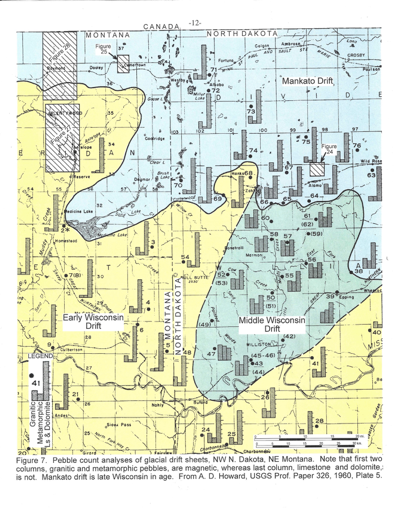
The site is located in the area covered by the Mankato Drift, far east on the on the high plains of Montana. The site is on one of the rare, remaining locations where the land was never broken, where the wind blows pretty much constantly, and where mammoths once roamed. More on mammoths as we move along with the research of this site.
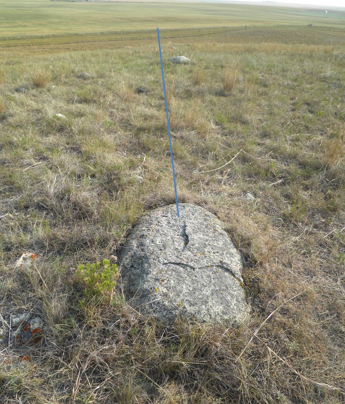
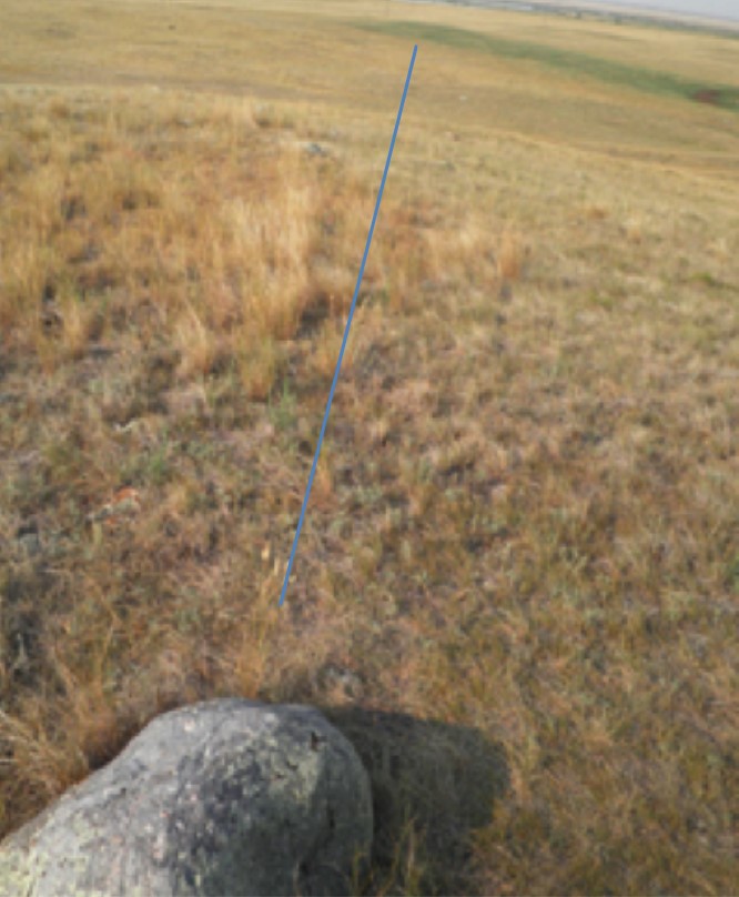
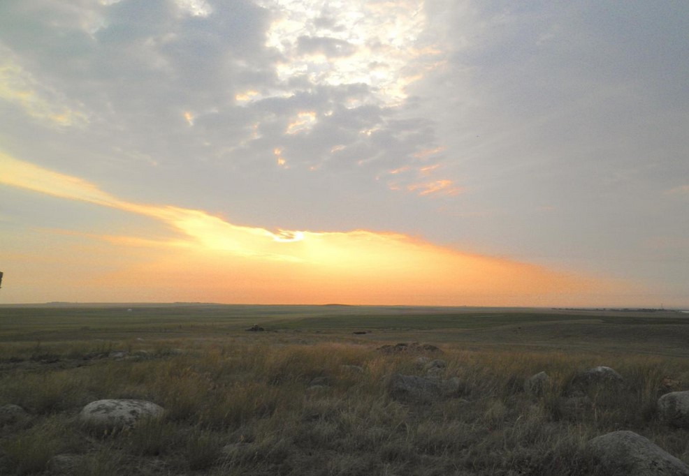 This photo was taken at the site. Early morning on the high plains.
I’ll begin with a geological overview of the area and a look at the early post-glacial environment. Then I will discuss the astronomy and geometry of the site.
The Geology
While there may be evidence of pre-glacial occupation, yet to be explored, today I will focus on results of the latest glaciations, their debris and the uses of that debris by early people.
Scattered across the landscape of North America, we find fields of glacial till featuring glacial erratics, which are stones not native to the area We find drumlins and even the occasional mascon, which is a magnetic anomaly. Montana has experienced both glaciers and fields of glacial till. The erratics left by glaciers include an abundance and variety of boulders, field stones and cobbles, ranging in size from larger than a Volkswagen to smaller than a grapefruit. These deposits are in a variety of sizes, colors, shapes, hardness and accessibility, some are buried or partially buried beneath layers of loess.
We can easily trace these concentrations of glacial till to the terminal fringes of glaciers. Where glaciers are active and moving, large stones can be suspended in the flow of the ice. These stones, dropped out of the melting and receding glaciers, become a part of the deluge of ice, water and stone left behind.
Some heavier stones may form the foundational composition of geologic features we know as drumlins or mascons. Sometimes, the stones piled up, catching more stones and building into mounds called drumlins. We find these glacial formations around the world, usually along the farthest advance of glaciers. Mascons are geologic features that present as magnetic anomalies. The present site appears to have magnetic characteristics of a mascon, and magnetic compasses are less accurate on these features. We have a couple more pieces of iron, placed by early European settlers, to remove from the site, and then we will be able to gain a better understanding of the magnetic features of the site. To side-step magnetic compasses, we are gathering a satellite GPS inventory of the locations of the stones at the site.
Remember, early people who created this site had no magnetic compasses, and relied on the relationships of stars, our moon and our sun, and the landscape, especially the horizon or prominent landmarks, to convey horizon events of the sun and moon to us, who would find them here, in their future for those early people. Some stone arrangements convey constellations and their stories, or simply the place of constellations in the heavens.
If I were a stone sculptor or a sky watcher, the edge of the receding Late Wisconsin Glacial re-advance, commonly called the Mankato Drift, would have been a wonderful place to live. Along and within this Drift, stones were moved, manipulated, manicured and utilized to create a remarkable record of the minds and observations of stone-age people. There is a language in these stones, in their placement, their relatedness, and the span of time their alignments may cover. Truly, these are observations and studies written with stones left for us to read, from our ancestors. This is a complex site, and has required much deciphering and continues to present enigmas.
You will note that it is more probable to have mascons in North Dakota, and that is the case. However, the Late Wisconsin/Mankato Drift area of Montana has its share of mascons, per Jeffrey Love, USGS. There is an abundance of glacial till all along the terminal edge of the Mankato Drift in Montana and North Dakota. And we have mascons here in Montana as well.
In northeast Montana, glacial erratics tend to be left behind along the terminal edge of the Mankato Drift, and it is in this area where I have concentrated my survey work, recognizing that large stones with expansive surfaces would invite human expression as rock art.
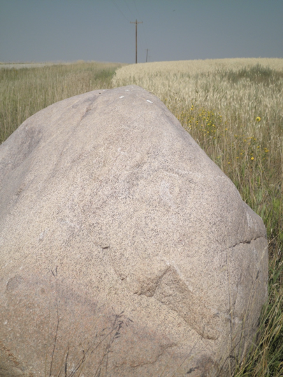
The first rock art I found in Mankato till was this marker on an erratic boulder near the North Dakota border. As you can see, it also serves as a perch for local raptors. It was a propitious beginning to my explorations. I decided to carefully examine large erratics for more petroglyphs. Later, I would discover that I was looking with the wrong set of eyes, because the significant rock art was not on the stones, but was, in fact, the stones themselves, arranged in patterns and often sculpted by early people.
Soon after finding this symbol on this boulder, guided by my Grandmothers, I found my first Mammoth, incised on a dolomite boulder. That mammoth will appear in a later paper on the sculpted effigy boulders of the Mankato Drift. I took this first symbol at this remote site as a symbol that I should look around that area for more sculpted boulders of rock art. And because the visual approach profile of this small boulder was of a trumpeting mammoth, I learned that I was looking with the wrong set of eyes, because much of the significant rock art was not on the stones, but might be the stones themselves, sculpted and arranged in patterns by early ice age humans. My search for early evidence of human occupation of the area became less focused on “drawings on rocks” and more focused on “sculpted rocks.” I began to more closely examine large dolomite and limestone as well as granite boulders, walking around them, spending time when the sun was at various positions, knowing that early people often used shadow and sun to help delineate the images they wanted to create.
The Environment Then and Over Time
Migratory patterns and migration coincided with seasonal shifts. Migrations took place with other life forms to optimize nutritional resources for all life forms. At glacial terminations, ice and land brought together a confluence of human life support, from natural resources, including the abundance of mega fauna. Ice melt flows, wind, blowouts, sand dunes, many along the old pre-glacial riverbed of the Missouri, supported megafauna at optimum size and characteristics to retain body heat.
Receding glaciers gave way to flourishing vegetation. Humans and animals, finding forage and food along new routes, formerly blocked from by coverings of ice, arrived and lived here as glaciers receded,
Humans may very well have been here prior to late advance of the Wisconsin glacier, following their protein sources on their annual migrations. Apparently, humans were here with the mammoths, and left mammoth effigies as well as other effigies. I consider that humans were here during long time migratory habitation, probably over thousands of years. Following their patterns of migration along with the other life in this area. As the glaciers receded and life advanced apace. Abundant resources included glacial till erratics, providing materials which became tools and art supplies for early artists. The melting glaciers left streams, rivers, loess made of ground stones,and the advance of animals along the receding edges of the ice. Artists came, skywatchers came, Bear Medicine Healers came. A permanent home base may have existed at this location over thousands of years.
Drumlins, created by melting flows, remained on the landscape as the glaciers retreated to the north. Drawn to elevated spaces for observation and of pleasing vistas, much as today’s people are drawn to vistas, people made use of these elevated spaces. There, they could not only observe the landscape, but the skies, the horizon, and the patterns of horizon events and movements in the skies.
Astronomy of the Site
Remember, these people were walking around on the ground, and able to created this site over extended times by observation, cooperation, and creativity. This site rises above the surrounding plains, and you will notice that the left side is darker and greener than the right side. The left side catches the prevailing wind and rain. The right side is in the rain shadow, but often catches falling dust as winds are slowed by the elevated character of this drumlin. There are other, significant drumlins nearby.
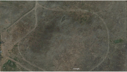
Satellite Image of larger site complex.
The ancient use of grids, lines and geometry are exact and remarkable. As we learn more about this site, we will no doubt continue to be impressed with its accuracy and continuity of observations made and recorded over extended periods of time.
The people how created this site were walking on the ground, and that remains the best way to discover and identify alignments, where stones are often hidden by changes in terrain, tall grass, or subsequent deposition. The construction of this site required the presence of observers and creators with a sense of continuity over many years of observation. Traditionally, sky watchers were women, and this site provides several indications that is it in fact a women’s site. That one fact will be subject of another paper, as will the presence of effigy boulders. Other sources inform me that this was also the location of the last Bear Medicine Lodge of the women of a certain group of people.
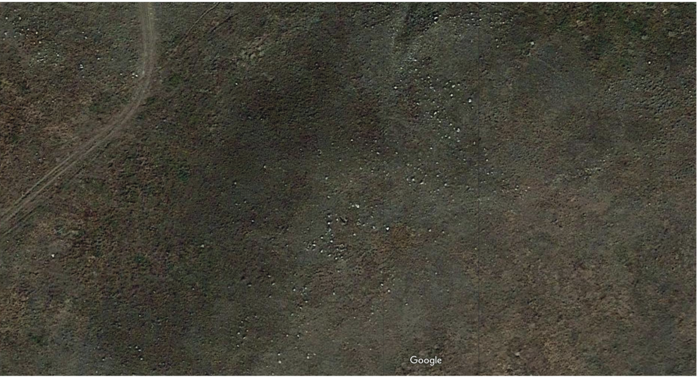
Satellite image of the center of the site
This image is a satellite photo of the central features of the site atop and down the sides of this drumlin/mascon. Just to the right of center in the top third of the photo, you will see the grid that I discovered last year, which is near the bottom slope of the drumlin to the north by northeast. It had been hidden by tall grasses, but the cows kindly grazed down the grass, exposing that feature. This grid that assisted me in the identification and validation through redundancy of more of the alignment patterns. Within the grid lines of larger boulders, there are also intermittent small stones to mark lesser stations of the movement of the sun rises and sets.
This grid reiterates alignments of both summer and winter solstice sunrises and sunsets over an extended period of time, probably thousands of years. I don’t have exact angle measurements yet. As you will notice on the lines in the next photo, lines continue through the grid and extend out to the northeast. There may be a slightly telescopic effect in the stones used to mark the alignments, which will be the subject of further research.
Here is another look at some of the identified alignments, not all the same as in the image above. Note the approximately 90 degree angles of the X created where summer and winter solstice events cross lines.
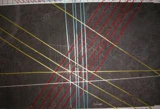
Summer Solstice Sunrise alignment
Winter Solstice Sunset Line
Continuity of observations over extended centuries and perhaps millennia is demonstrated by the array of lines extending from stations stones. People lived and worked, at this place and observed and recorded horizon events and perhaps other sky phenomena. Many stones are not visible in these photos. Many stones and lines of stones can be discovered only by walking the site. Most of the discovered lines of stones appear to be aligned to horizon events.
Satellite maps cannot replace human eyes. Many stones are obscured by tall grasses, are partially or almost completely buried, and only found during my walking observations of the immediate area. In person. On the ground.
This is the slow process of walking the site, using visual recognition of lines of 2 or more stones, then following the line in both directions, twenty feet or more each way from those initial alignments. When you are out in the field, remember to look for lines of stones.
These may be drive lines, alignments with horizon events, or serve other purposes then the satellite maps, now more GPS work and more math and geometry will occupy the next two or three years. More detailed photographs, coupled with more careful examination of the site through more walking around will constitute future work.
This ancient, scientific, deeply sacred site cared for and created in the past, belongs to all of humanity. Here, people observed, considered, and created a message of their observations which has endured over time. Although the site has been somewhat disturbed by recent activity within the last hundred years, and some of the stones have been moved or removed, enough remains that I was able to discover and to begin to decipher this site. I want to emphasize that this site was built by people who worshipped the Creator of all that is. With the creation of this site people could more closely connect to the Mind the Maker. It is a very sacred place, and I hope that such sites will be treated with respect and care in the future.
Many of the sites nearby on government land have been looted and destroyed. Only remnants of those sites remain. The further study of this mostly intact site will lead to greater understanding and better identification of those already looted and partially-destroyed sites created by earlier people, and help us to understand our shared past and the people who lived here for thousands of years. Such sites give us a window into deep time and the thinking and creativity of early people. The beauty, wonder, sacredness — as well as the thought and effort that went into the creation of this site need — to be respected and protected from further vandalism, destruction and theft.
This site is a part of the heritage of all humans, and as such, it deserves to be preserved and protected, studied — and shared with the world.
You will recall that shifts in celestial alignments were noted and recorded during times of occupation of the site perhaps intermittently . Sunrises, as we know, move along the horizon with the seasons, and were thus recorded as changing horizon events. Thus far in my investigations, several lines of stones appear to be station stones for major solar events. From those stones, one or more lines may lead to a horizon event, such as Summer Solstice Sunrise or Winter solstice sunset. But that’s another paper.
In conclusion, early people who lived in this environment that is quite different from today’s environment were observant, creative and cooperative, as well as communicating among themselves to create this enduring record in stone of their observation of events in the sky and along the horizon over extended time.
Nonetheless, they took time to observe and create a record of the events happening in the sky above them. They left us a record of their observations, written in and on stones.